Monday, June 24, 2019

June 24 Sylvan Beach to Brewerton.


June 24

Oneida lake is an almost straight westerly  20 mile crossing  so  winds  like those yesterday running 15-20 knots  from the NW have a chance to build up  some nasty waves in the relatively shallow lake. We saw them crashing  on the breakwater going out from Sylvan Beach  and felt them on the wall where we were tied up, so we were glad when the wind settled last night with a promise for a light  SE  breeze today.  
Leaving the Sylvan Beach breakwater
The forecast held and  we had a very smooth and uneventful crossing  to Brewerton with the exception of getting swarmed  by little bugs attacking the boat and the clusters of fishermen on their boats trolling and jigging for bass and walleye.
Clear skies, sunshine, calm seas and open water behind us on Lake Oneida


We put in at Ess-Kay marina, topped off the fuel tanks with 116 gallons of diesel and secured a slip. It looks like we’ve gone about as far as we can go for the time being.  They have had copious amounts of rain up here and most everything is still experiencing high water which is impacting lock operations on the Oswego canal . We’ve been hearing about it and it’s one of the reasons we slowed down and took extra time  visiting  the smaller towns along the Erie canal.

Just past Brewerton we end our transit  of the Erie canal.   While it continues westward all the way to Lake Erie we exit the Erie canal and  head north on the Oswego canal  going towards Lake Ontario.   All these waters are now flowing outbound.  Lake Oneida flows through the Oswego canal into Lake Ontario which flows into  the St. Lawrence which flows into the Atlantic  some 750 miles from Lake Ontario.   All this water is still backed up (Lake Ontario is 3’ above normal).  The high water and especially high outflows over dams adjacent to the 7 locks on the Oswego canal have them temporarily closed to boaters for safety reasons.  Adding to this dilemma is a forecast for more rain over the next few days.      We’ve got a nice protected slip here at Ess-Kay and will just wait it out along with other loopers until things open back up.  Really no other option.   This isn’t completely unusual.   Several years ago   there were a group of loopers trapped on a section of the Erie for 2 weeks because of high water problems.  Let’s hope our stay is shorter.   It's been a fun 2 months getting to this point but some of the best sections of the loop lie just ahead.  The Thousand Islands, the Trent-Severn Waterway, the Georgian  Bay, and the North Channel  are calling us forward to spend the summer on their waters!!
Journey for June 24 - note the red blip on our travel line where I ran WOT to blow out the turbo

Sunday, June 23, 2019

June 23 Utica to Sylvan Beach


June 23

Late start today from Utica as we only  had 20 miles and 3 locks to traverse and we wanted to get to Sylvan Beach later in the day hoping the crowd at the town walls would have started to dissipate.  Nice sunny day reaching into the upper 70’s along with a jet ski competition had the crowd out in full force. We pulled in around 3:30 and found a spot but not ideal and we’re still hoping later in the evening to move to another section of the wall further back from the jetty that provides more protection from the wave action coming in from Lake Oneida.
Busy day on the water at Sylvan Beach


The only significant town we passed after leaving Utica was Rome.  Claim to fame is they once mined 10% of all copper in the US.  It is also home to Ft. Stanwix – a reconstruction of a wooden fort originally built in 1758.   From the water all you see is a bridge and a long town dock that looks inviting but on closer inspection is in pretty rough shape.  
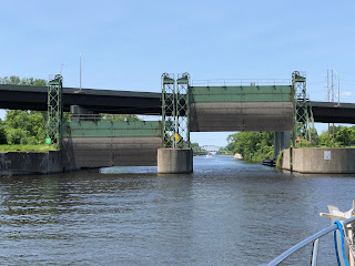
Flood Gate at Lock 20 that was shut closed and caused our delay at Little Falls


Most of our travel on the Erie canal has actually been through dammed up sections of the Mohawk River (that was the 3rd and final enlargement in the early 1920’s).  As we approached our maximum elevation of 420’ at Lock 20   the Mohawk became smaller and unnavigable and so this entire section is the true man-made canal portion.   Some wildlife along the way with deer, geese, ducks, turtles and herons all spotted.
A big brood of new hatchlings trying to keep up with Mom


Locks 21 and 22 are down locks so a new technique had to be used for grabbing the lines and handling the boat as we were lowered.  Not difficult – just different.   Each of these locks took us down 25’ to the same 370’ elevation as Lake Oneida, a 20 mile long lake we’ll cross tomorrow.

Sylvan Beach is a central NY summer  destination sitting on the shores of Lake Oneida with a full time population of 892.   In it's heyday back in the turn of the century it was known as the "Coney Island of cenral NY" with thousands visiting the nice sandy beach, two amusement parks, hotels and restaurants. 
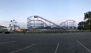
Not quite Coney Island 
Today it's  still a small village with the same nice beach, a small amusement park, good fishing and lots of boaters with easy access to the lake.    There are some hearty people up here.  Physically very stout  and not ashamed to show their bodies off in their bathing suits.  And apparently immune to cold as they must go out sunbathing when it’s 40 degrees out based on some of the dark tans.  Pretty crazy watching all the boats and people while tied safely to the wall.
Sylvan Beach 
Promenade  and park area at Sylvan Beach
Good place for some  sunset pictures over the lake 

Journey for June 23


Saturday, June 22, 2019

June 22 Little Falls to Utica


June 22

It's officially summer according to the weatherman.  Not sure anyone up here got notified as it's been in the 50's  when we wake up and only getting into the low 70's  even with plenty of sunshine. With low humidity and a stiff NW breeze it's quite a change from the 90's we expect in GA this time of year.  Sweatshirts are still a normal part of our wardrobe in the mornings.
 We wound up being “trapped” in Little Falls for an extra day since the canal was closed due to the high water from the storm.  Not an issue for us as we planned to stay anyway to rest up and explore a bit more. With high water creating problems and delays in our next sections  - the Oswego Canal and the Thousand Islands – we continue to take our time and pace ourselves.
Even the town ducks knew not to get in the flooded river

 We had a full dock here with 9 boats tied up at the city marina with no one able to leave but also no additional boats coming upstream.  For a small town they have done a great job with their volunteer staffed dock.  Extremely welcoming and very helpful.

We slept in late on Friday for a change of pace and cooked up a nice breakfast on the boat.   Did a few boat chores (it’s amazing how dirty everything gets going through these locks) and then walked to town and visited the historical society museum, got a few supplies at the hardware store and meandered through some shops.  An early dinner at the Copper Moose again and another flight of local craft beer.  Sampled a selection of central NY lagers, porters and stouts Thurs. so went with an assortment of IPA’s on Fri.  The Agave Tequila IPA was pretty amazing and I’m not even an IPA guy.

Notification came out Fri night that the canal would be reopened westbound through lock 20.  Our plan was to go the roughly 20 miles and hit Utica next so only needed to get through locks 18 and 19.  The current was still running a good knot against us  but most of the debris seemed  to have flushed out so after a hearty stack of blueberry pancakes from Ann’s Diner  we headed off in the still flooded and chocolate milk colored water.  Despite a fairly stiff NW breeze at least it was clear and sunny.
Chocolate milk colored waters 
Gov. Roosevelt tug - built in 1928  and still in service 


Lock 18 was waiting for us with open gates.  Just us and Cat and Dogs so plenty of room and no issues.  At Lock 19 we had to wait a few minutes and a third boat joined us.  Still plenty of room for all.  The Utica dock is a bit small bit since no one was there we had plenty of room to tie both boats up on the floating pier section in deeper water.  
Under the 20' clearance RR bridge and into the awaiting lock 19

Martha holding tight lines in the lock - did I mention it was 53 degrees this AM
Exiting lock 19 with RR bridge now level with us

Downtown proper is a fair distance from the canal, so we walked the 1-1/2+ miles to get to a brewery tour.  West End Brewery was founded in 1888.   At some point they changed the name to F.X.Matt Brewery after their founder but it’s really known by most  everyone by it’s brand name - Saranac brewery.  Claim to fame - their Utica Club Pilsner (still made today) was the first beer sold after Prohibition ended.   Pretty good tour for $5 and then you get a token good for a pint at the tasting room.   Along with beer they also produce nonalcoholic carbonated drinks (soda) and also do consignment brewing for other craft breweries.   Due to it’s size, I’m not quite sure I’ld call it a craft brewery as much as a regional brewery.


Utica is a bigger city than most of our stops on the canal.  It’s more difficult getting around and despite it’s merits of having a  university, an up and coming food scene, some good arts programs and a proposed major medical center  to replace the blighted area  we had to walk through  to get to the funky brewery area, the town still just felt run down and disjointed.   Maybe if we had a car and could explore the city easier my impression would be different.   Anyway – on to Sylvan Beach tomorrow.
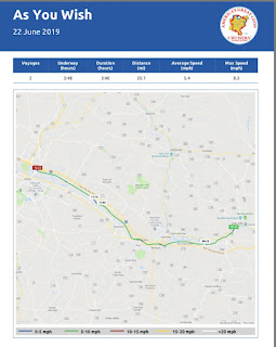
Journey for June 22

Thursday, June 20, 2019

June 20 Canajoharie to Little Falls Locks 14.17 Flash Flood!!


June 20

After seeing all there was to see in Canajoharie and despite a forecast calling for a day of heavy rain and possible lightening/thunder  we headed out at the first   opening of lock 14 at 7 AM hoping to make some progress on our way to Little Falls before the rain set in.  Our plan worked as we passed through locks 14 and 15 but by the time we approached lock 16 the skies started opening up.  Lock 17 with it’s 40’ lift (the highest single lock lift on the Erie canal)  and slow fill rate was looming ahead.  While the rain eased up occasionally we still  got pretty wet (Martha much more than me) handling the lines before exiting the lock.  
Heading up the Mohawk River

Waiting our turn to pass through the 40' lift of lock 17

Entering lock 17 with it's unique guillotine gate instead of doors

Flood gate #4.  We got thru before they closed them to control the water flow

Thankfully Little Falls was just a bit further and we got quickly and securely tied up to the floating dock.   Flash flood notices were showing on the weather apps so we were glad to get inside, get our wet clothes off, reheat some Italian food for lunch and take a quick nap.  Amazingly, the Mohawk River was quickly rising to flood stage and water at the dock had risen a good 4 feet, large trees and limbs were floating down the river, they had closed the flood gate between us and lock 17 and had closed all traffic through locks 18 and  19 ahead of us.   The rain we received  here was  just on the fringe of a significant front with a lot of rain to the north and west that all feeds down into the Mohawk.


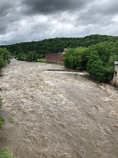
Mohawk River raging through Little Falls


At this point we’re not sure how much higher the river may go or when they may  reopen the canal.   Lots of speculation but we’re waiting for the canal authority to issue some official notices.

Flooding at the town dock


In the meantime, the rain let up in Little Falls in time to head into town.  They have a unique Arts Walk on the 3rd Thursday of each month (which happened to be today).  The town still has a nice and active downtown and each store displays  a different artists  work in their front window a different musician  in the middle of each block.  It’s very well attended by the local citizens. 


Great downtown area in Little Falls

  I’ll also mention they have a very nice pub in town with 30 craft beers on tap.    We’re looking forward to spending an extra day here and exploring the town further. Like most towns along the Mohawk it’s history goes back to factories built in the 1800’s  that used water power from the river to run the plants.  This was also a famous  cheese producing region  based on the superior local dairy farming.

Old factories along the river converted to an antiques mall and condos
Picturesque area

The day ended  with some nice sunshine

Journey for June 20

Wednesday, June 19, 2019

June 19 Amsterdam to Canajoharie Locks 11-13

June 19

Another short run today had us tied up before 1PM at the free town dock at the waterfront park in Canajoharie after traveling  just 22.4 miles   through 3 more locks but only up another 31'.   The currents approaching  and entering these locks can be wicked and suddenly move you dramatically sideways.  We're learning to approach them under power and  push through and into the  lock and then ease off quickly, grab some lines and power to a stop.
All this water flows downstream  alongside the lock entrance

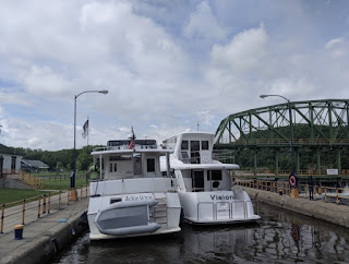
Overall, the trip was going well until we got to our last lock of the day  - Lock 13.  A larger boat  had left Amsterdam well before us  but was slow and got held up in the lock as we approached.   The captain was really belittling the lockmaster for waiting on us rather than letting him lock through.  Well, don't you know we wind up right next to him which wasn't too bad  until the lock gates closed and  the chamber started filling at which point they lost control of their lines and drifted against us.  His big boat simply pinned us to the lock wall.  It wasn't an issue initially but once the lock completely filled there wasn't even room for a fender  between us and the wall. Thankfully no damage to either boat but not a fun experience.  He continued past us and hopefully will remain well ahead of us.
"Vision" loose in the lock and using "As You Wish" as a fender -  Aaarrrghhh!!!

Beautiful scenery continues along the Mohawk River

Even along a scenic waterway civilization  occasionally pops up

Canajoharie is an indian word meaning "pot that washes itself" and describes  several large round depressions in a nearby creek that  formed in the rockbed over centuries by circular flows of water eroding away the stone.   They're a bit outside of town  so we opted to visit the nearby Arkell Museum.    Bartlett Arkell was the first president of Beech-Nut packaging based here in Cananjoharie.  It was (is) a very large factory built in the early 1900's along the Mohawk River  as  their processing and packaging plant. This site gave them an advertising advantage with it's clean, natural, fresh and wholesome location.   While I remember Beech Nut gum as a kid I didn't realize how diverse they were back in their heyday  of the 20's and 30's when they had a diverse  line of packaged foodstuffs including bacon, crackers, cooked spaghetti,  fruits, ketchup, etc. as well as their gum.   Bartlett loved the arts and wanted to share with his workers and community.  He initially had copies of the masters commissioned  that were displayed in the factory areas (along with piano playing  in the factory and manicures for the female workers).   In the late  20's he  established a library and  museum  to share his art collection with the entire community.  The business was sold off in the 50's   and the plant now sits idle and abandoned.  A reminder of better economic times.

Canajoharie  has a very unique stoplight in the town center.  They call it the "Dummy Light".   It's a 4 sided light mounted  in the center of  an intersection.  The dummy part comes from the fact that there's 5 streets entering the intersection.
The dummy light

Interesting dining option in town tonight.  Irish pub that stopped  serving food after 2 pm when the cook went home,   A diner that only serves breakfast and lunch or your choice of 3 different  Italian restaurants - so we had Italian again tonight.

Journey for June 19


Tuesday, June 18, 2019

June 18 Scotia Landing to Amsterdam Locks 8-10


June 18

Awoke to a cooler dreary looking morning with a forecast  for possible light showers in the morning but clearing and warming into the mid to upper 70’s – a veritable heat wave  for us lately.  We managed to depart the docks  at Scotia  without issue despite the  side current and headed up the Mohawk to lock 8.  

Smooth sailing on flat calm waters


The original Erie Canal from the early 1800’s was a completely man made  narrow and shallow cut that followed along the banks of the Mohawk River.   That canal allowed mules to pull the relatively small barges both up and down the canal without worrying about the rapids, shallows or high spring waters of the river.   It wasn’t until the big expansion of the canal in the early 1900’s that technology was available to dam the rivers  and fabricate the big locks that make the river navigable today.   Along  the current route you can still find remnants of the old  canals  such as an old stone wall or remains  of an aquaduct.
Remains of old aqueduct that carried canal across the Mohawk


Todays trip was relatively short.  Just 20 miles and 3 locks taking us to Amsterdam.   They have a great park on the waterfront with a nice dock and wall for overnight mooring.  Six looper boats here tonight.  The town has built pedestrian   walkways that take you from the park across the river to South Amsterdam as well as another pedestrian bridge taking you over the busy railroad tracks and Route 5 to Amsterdam proper.
Statue of mother nature in park

Reproduction of ancient Indian pictographs that were on a wall along the river in 1800's

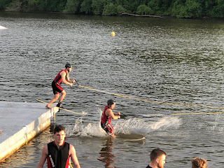
 Interestingly,  we got another  exhibition tonight by the local water ski club who were practicing for a show they were doing in 2 weeks.  I guess  the locals  take advantage of any sunny day  they get this time of year but it sure looked cold to me.


Amsterdam was a very  industrialized city in the 1800’s.  Partially due to it’s location along the canal and ability to move manufactured goods both east and west.   But that industrialization was actually made possible by the water flowing through town in the Chuctanunda  Creek that was used to power  the hosiery, carpeting and paper mills along it’s route.


Todays locks each  only lifted us about 15’ but it seemed like entering them was a bit trickier as they were all next to dams that were discharging a good amount of water that created swirling water around the entrances.   Thankfully just 2 boats  going through the locks together today so quick and easy passage once we got in and secured. 

Entering lock 8  on the left side with a hellish side current from the right


Mohawk River flow is still significant creating a .5 knot current or more


  We did hit a little drizzly weather   during the trip  but my crew hung tight  to the wet and slippery lines to get us  safe passage. 

The afternoon  turned out quite delightful with sunshine and  those promised 70 degree temperatures.   We had a good walk over to South Amsterdam and another great Italian  dinner.   This is still NY after all and if you can’t get good Italian food here you’ll never find it!!

Amsterdam Castle B&B - former home to the New York Army National Guard Armory. 

Journey for June 18